Shareholder update sent in September 2026, reproduced as sent. Information speaks as of that date; see later updates for current status.
We are pleased to update shareholders on the completion and analysis of the induced polarization (“IP”) geophysical program at the Company’s Bahila prospect (licence AA-12, Al Amar project), Saudi Arabia. The survey has defined 175 chargeability anomalies organised along three structurally controlled trends, spatially coincident with the porphyry-style molybdenum-copper surface anomaly reported in our June update. Drill planning is well advanced, and we expect to announce the commencement of our initial drill programme at Bahila imminently.
Summary
- Survey complete – 104 km of IP surveying across approximately 20 km² at Bahila, imaging sulphide targets from near-surface to ~1,000 m depth. A radiometric survey has also commenced, with 405 km completed, and the program to recommence in September’s cooler temperatures.
- 175 targets along three trends – including 55 first-priority targets aligned along three parallel, fault-controlled trends. The central trend runs ~3 km and is open to the north; the eastern trend carries the strongest response on the property, lies largely outside the surface geochemical anomaly and is open to the south.
- Shallow, drill-ready targets – priority anomalies begin 50–250 m below surface, including a near-vertical body on the central trend extending over 600 m vertically from ~50 m depth.
- Aligned with surface results – the three trends converge on the ~8 km² molybdenum-copper anomaly reported in June (peaking at 1,450 ppm Mo, with copper values to 1.42% Cu).
- Drilling next – drill planning is well advanced. We expect to announce the commencement of our initial drill programme imminently.
1. Bahila
Bahila is the most advanced prospect in the Company’s portfolio and the focus of our initial drill programme. The prospect lies within the Ar Rayn terrane, a Neoproterozoic continental-margin arc on the eastern margin of the Arabian Shield, interpreted as directly analogous to the Andean margin of Chile – the setting that hosts the world’s largest porphyry copper and porphyry molybdenum deposits. The Bahila ground sits adjacent to the Khnaiguiyah zinc-copper deposit (JORC mineral resource of 73.5 Mt grading 2.26% Zn, 0.20% Cu and 1.65% Mn per Ajlan & Bros.), and Ma’aden’s producing Al Amar gold-zinc-copper mine lies approximately 35 km to the southeast.
Exploration at Bahila has been built up in sequence. A magnetic survey and 3D inversion first identified a large magnetite-destructive low interpreted as a buried intrusive centre. Field mapping and sampling of that feature returned high-grade copper at surface (up to 1.4%) and defined the alteration and metal zonation characteristic of a porphyry system. Based on those results, we commissioned an IP survey to test for sulphide mineralisation at depth.
2. Magnetics
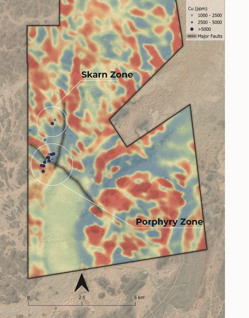
Regional magnetics was the first dataset acquired at Bahila and the basis for subsequent programs. A 3D magnetic inversion (completed by in3D Geoscience in February 2026) displays a ~1 km magnetite-destructive, circular magnetic low, interpreted as hydrothermal alteration above a buried intrusion, passing downward into a substantial magnetic body from approximately 700 m depth. Magnetite destruction on this scale is characteristic of the potassic and phyllic alteration that envelops porphyry intrusions. The geometry of a discrete low sitting above a larger magnetic body, is the signature expected of a potentially concealed magmatic-hydrothermal center.
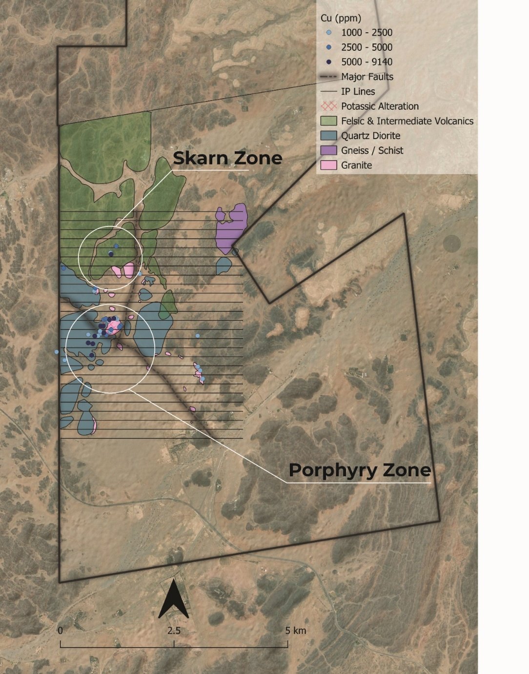
That interpretation, paired with preliminary field investigations set the framework for additional exploration and the development of further geological targets. We discovered that the magnetic anomaly is flanked by the skarn target to the north and the porphyry target to the south (Figure 2), and mapping and sampling was completed across the magnetic anomaly and its margins to test whether the alteration, metal zonation and copper mineralisation expected of a porphyry system were present at surface.
3. Surface Geochemistry and Geology
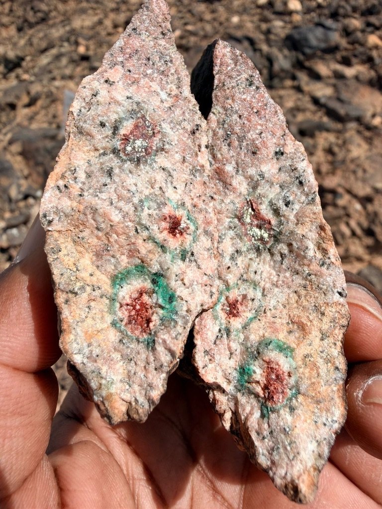
Field mapping and sampling directed at the magnetic anomaly and its margins confirmed the porphyry interpretation at surface. As reported in June, this work defined the coherent footprint of a porphyry-style system around the magnetic anomaly: a molybdenum halo of approximately 8 km² peaking at 1,450 ppm Mo, centred on potassic-altered granite; approximately 1 km of garnet-diopside skarn to the north; and copper-bearing quartz veining to the southwest, with 16 samples above 0.5% Cu (to 1.42% Cu). The tenor and zonation of the molybdenum-copper-bismuth anomaly are characteristic of porphyry systems, and the high-grade copper returned from surface sampling (Figure 3) demonstrated that the system is mineralised, not merely altered.
The Company’s surface geological mapping, conducted independently of the geophysical programs, identified a >3 km corridor of quartz-sericite-pyrite alteration with disseminated sulphides along a porphyritic dyke corridor, a potassic-altered sulphide-bearing intrusion, and copper occurrences along an andesite-granite contact.
Together, the magnetics and surface results define the footprint of a potential porphyry-style system: a buried intrusive centre, high-grade copper at surface, a zoned metal anomaly and the alteration that accompanies it.
4. IP Program
With a potential buried intrusive centre defined by magnetics, and confirmed high-grade copper and porphyry-style alteration at surface, the IP program was designed to test for sulphides at depth. Induced polarization surveying measures chargeability – the capacity of subsurface material to store electrical charge – a response caused primarily by disseminated sulphide minerals. Because porphyry deposits are characteristically enveloped by laterally extensive pyritic alteration halos, IP is a primary geophysical method for targeting concealed porphyry mineralisation ahead of drilling. The survey was designed to establish whether sulphide mineralisation persists beneath the surface anomaly, to map its distribution and structural controls, and to define drill targets.
Simcoe Geoscience completed, and reported, on a 104 line-kilometre IP and resistivity survey in Q2 2026 on 200m line spacing, with imaging from near-surface to approximately 1,000 m depth.
Following receipt of the final report, the Company engaged in3D Geoscience Inc. to independently analyse the dataset. in3D re-imported the raw field data, re-examined each measurement through independent quality control, re-inverted all data using an independent inversion methodology with per-line error tuning and depth-of-investigation analysis, and constructed a 25 m block model interpolated from the re-inverted lines across the full survey volume. This work, delivered in August 2026, provides a second, independently derived model of the survey and forms the basis of the drill-targeting framework, alongside the 3D magnetic inversion completed by in3D earlier this year.
5. Results
5.1 Anomaly framework
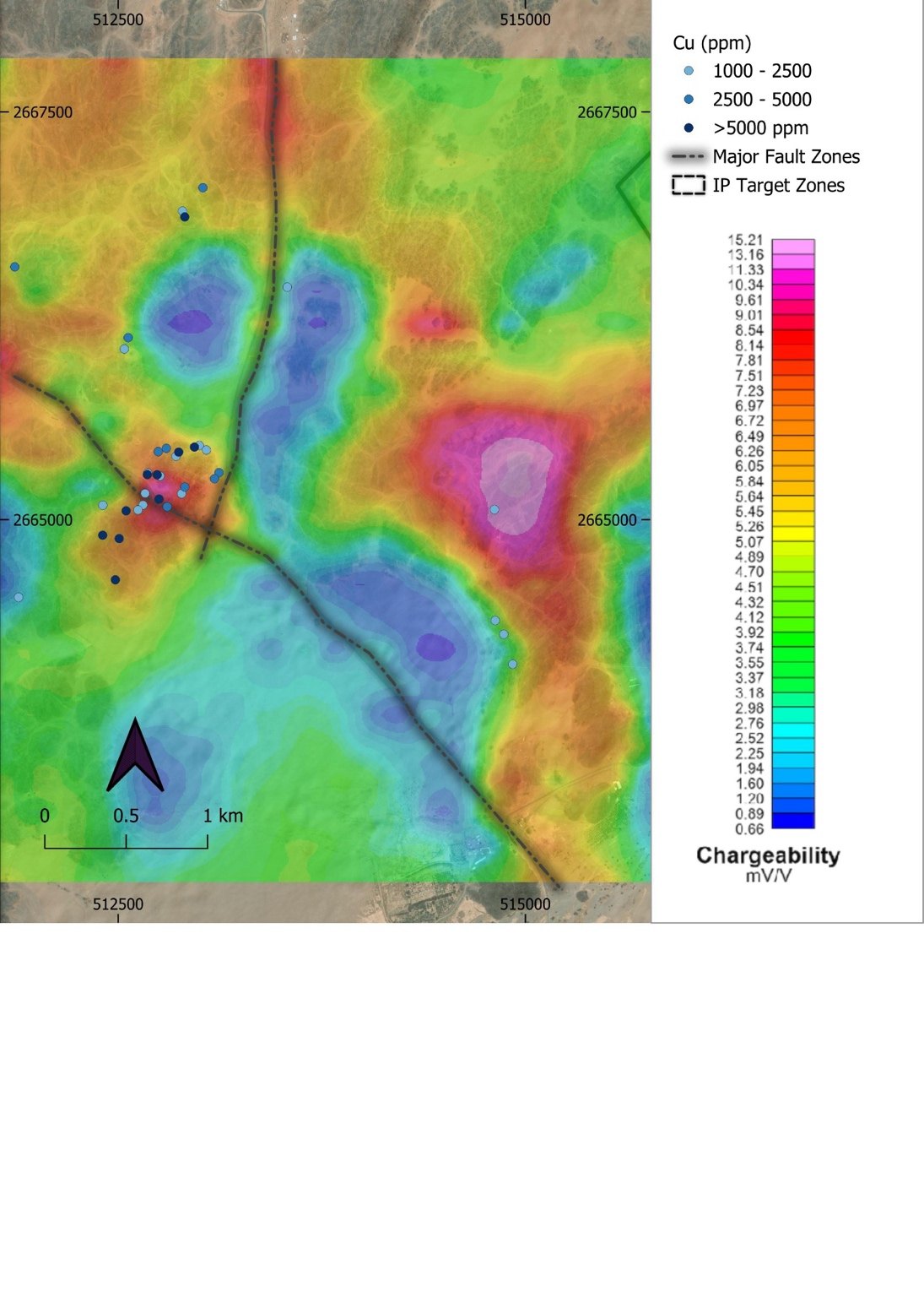
The survey identified 175 discrete chargeability anomalies (55 first priority). First-priority anomalies combine strong chargeability with low resistivity, the geophysical response associated with interconnected sulphide mineralisation. The anomalies sit on three sub-parallel trends around two structures interpreted from the resistivity data: a ~3 km north–south fault through the central grid, and a ~4.5 km northwest-trending fault through the southern grid (Figure 4).
- The western trend underlies the surface molybdenum-copper anomaly and the potassic-altered intrusion mapped at surface.
- The central trend follows the north-south fault continuously for approximately 3 km through the northern half of the grid and is open to the north. It is coincident at surface, to within 20 m, with the mapped porphyritic dyke corridor and >3 km of quartz-sericite-pyrite alteration with disseminated sulphides.
- The eastern trend carries the strongest chargeability response on the property, dominates the southern half of the grid, and is open to the south. It lies largely beyond the surface geochemical footprint and was not identified by surface work.
5.2 Section results
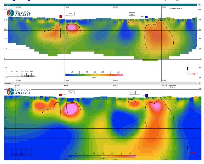
The inverted sections image sulphide distribution in the third dimension. Beneath the western and central grid, a chargeable halo – interpreted as the pyritic alteration shell of the target system – is modelled from approximately 150–250 m below surface, beneath a low-chargeability cap consistent with the weathered and leached zone observed at surface. On the central trend, the sections image a discrete, near-vertical chargeable body approximately 200–300 m across, sitting within approximately 50–100 m of surface and a vertical extent of at least 600 m (Figure 5). The body is coincident at surface with the porphyritic dyke corridor, the quartz-sericite-pyrite alteration corridor and the north-south fault. In porphyry systems, sub-vertical chargeable bodies of this geometry are commonly associated with mineralised feeder structures. Drilling is required to confirm the specific nature of the sulphides.

5.3 Additional modelling
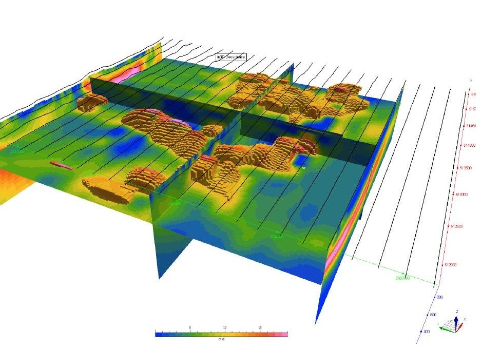
Re-inversion by in3D substantially confirmed the principal anomalies – the central-trend chargeable body, the western-central chargeable halo and the eastern trend (Figure 6). The 25 m block model prepared by in3D (Figure 7) allows anomalies to be interrogated in three dimensions against the geological, geochemical and magnetic datasets and is a key framework with which we are planning the upcoming drill program.
5.4 Integration with magnetics and geology
The IP results constitute a third independent dataset, consistent with the architecture already defined by the magnetic inversion and surface mapping. The chargeable halo beneath the western and central grid wraps around the magnetite-destructive low described in Section 2, and the three chargeable trends coincide with features already resolved at surface: the central trend with the >3 km quartz-sericite-pyrite corridor, the western trend with the potassic-altered, sulphide-bearing intrusion, and the eastern trend with the copper occurrences along the andesite-granite contact. Field mapping, magnetics, and two independent IP models thus converge on the same structural architecture.
6. Interpretation
Chargeability reflects sulphide content and texture, but does not confirm deposit style size. Our interpretation rests on a combination of datasets: a large, fault-related or fault controlled chargeable system lying directly beneath a zoned molybdenum-copper-bismuth surface geochemical anomaly whose tenor and zonation are characteristic of porphyry systems. These chargeable features are wrapped around an interpreted magnetite-destructive magnetic anomaly. Our working hypothesis remains that a buried, fertile porphyry intrusion potentially underlies the magnetic anomaly, with the skarn, copper-bearing veins and quartz-sericite-pyrite corridor representing its near-surface expression.
7. Next Steps at Bahila
- Initial drill programme – targets have been ranked from the integrated model; we expect to announce the commencement of drilling at Bahila imminently.
- Constrained 3D inversion of the IP dataset to refine deeper targeting as drilling advances.
- Assay results from recent surface sampling campaigns (167 samples pending).
- Integration of ongoing radiometric and hyperspectral surveying and analysis into the targeting model.
About Greyridge
Greyridge Exploration Corp. is focused on discovering copper and gold deposits on underexplored, highly prospective ground in Saudi Arabia. The Company holds 25 licences (1,817 km²) situated on and near defined gold and copper mineral belts of the Arabian-Nubian Shield.
Qualified Person
The scientific and technical information in this update has been reviewed and approved by Darren Lefort, a “Qualified Person” as defined under National Instrument 43-101 – Standards of Disclosure for Mineral Projects. Chargeability and resistivity anomalies are geophysical features that indicate the possible presence of sulphide minerals; they are not measurements of mineralisation, grade or tonnage, and there is no assurance that drilling will intersect mineralisation. Anomalies described as “open” are unconstrained at the survey boundary; this denotes the limit of geophysical coverage, not demonstrated continuity of any geological feature. Rock chip and trench sample results referred to in this update are selective in nature and are not necessarily representative of the mineralisation hosted on the licences. Individual sample assays do not constitute mineral resources or mineral reserves as defined under NI 43-101 and CIM Definition Standards.
Forward-Looking Information
This update contains forward-looking information within the meaning of applicable Canadian securities legislation, including statements regarding the timing and announcement of the planned drilling programme, the interpretation of geophysical data, interpreted geological and deposit models, and anticipated exploration results. Forward-looking information is based on assumptions and is subject to known and unknown risks and uncertainties – including exploration risk, the inherent uncertainty of geophysical interpretation prior to drilling, commodity-price volatility, permitting, and contractor and assay-laboratory availability – that may cause actual results to differ materially from those expressed or implied. References to deposit-style analogues and to neighbouring deposits (including the Al Amar mine and Khnaiguiyah) are for geological context only; mineralisation hosted on, or grades and tonnages associated with, neighbouring properties are not necessarily indicative of mineralisation on Greyridge’s licences. Readers are cautioned not to place undue reliance on forward-looking information, which speaks only as of the date of this update. The Company undertakes no obligation to update forward-looking information except as required by law. Additional risk factors are described in the Company’s continuous-disclosure filings available on SEDAR+.