Shareholder update sent in October 2026, reproduced as sent. Information speaks as of that date; see later updates for current status.
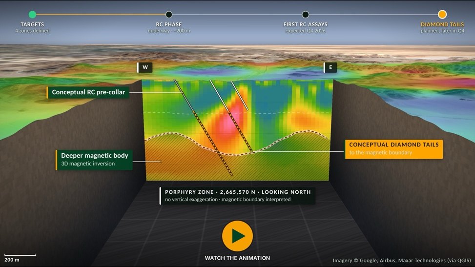
We are pleased to announce that drilling is well underway at our Bahila prospect (licence AA-12, Al Amar project) in Saudi Arabia. The program comprises more than 5,000 metres of reverse circulation ("RC") and diamond drilling, testing the four targets we have defined with magnetic, induced polarization ("IP") and surface surveying, as reported in our last update. We are using a single dual-purpose rig to rapidly test the four targets with RC drilling. We then expect to extend selected holes with diamond tails to test the core of the Bahila chargeability system and the deeper magnetic body.
Our team is safe, and the regional security situation has not affected our operations beyond periodic restrictions on drone use. We continue to monitor events closely. Brendan Cahill (CEO), Ben Pullinger (Director) and Michael Bradley (VP Corporate Affairs) will be visiting Riyadh and our projects at Al Amar during October.
Summary
- Drilling well underway – RC drilling is well underway at Bahila, the most advanced prospect in our portfolio, with a program of more than 5,000 m of RC and diamond drilling.
- Four targets – the program tests all four targets (the Porphyry Zone, Skarn Zone, Central Trend and Eastern Trend), defined by the magnetic and IP surveys and surface geochemistry. The Porphyry Zone, the potential porphyry core, is our primary target.
- RC for broad, rapid and cost-effective coverage – RC drilling to approximately 200 m depth tests a broad area across the four targets for the right host rocks, alteration and sulphides, and returns the first bedrock samples beneath the weathered, leached cover.
- Diamond tails to test the chargeability core – the strongest chargeability and the deeper magnetic body lie largely below the reach of RC drilling. Based on the geology encountered in the RC holes, we expect to plan diamond tails on selected holes to test them at depth.
Bahila lies within the Ar Rayn terrane, a Neoproterozoic continental-margin arc on the eastern margin of the Arabian Shield, interpreted as analogous to the Andean margin of Chile. The ground sits adjacent to the Khnaiguiyah zinc-copper deposit, and Ma'aden's producing Al Amar gold-zinc-copper mine lies approximately 35 km to the south.
Four independent datasets, described in our last update, point to a possible buried magmatic-hydrothermal system: a ~1 km magnetite-destructive magnetic anomaly above a deeper magnetic body; a potassic-altered, sulphide-bearing intrusion with skarn and quartz-sericite-pyrite alteration around it; an ~8 km² molybdenum halo with copper to 1.42% at surface; and a chargeable halo imaged by IP beneath a weathered, leached cap.
2. RC Drilling Program
The program tests the working hypothesis set out in our September update: a buried, fertile porphyry intrusion beneath a magnetite-destructive magnetic low, with the skarn, copper-bearing veins and quartz-sericite-pyrite corridor as its near-surface expression. We designed the holes in the in3D Geoscience 25 m chargeability block model and ranked them on the coincidence of geology, geochemistry and geophysics. Golden Compass Mining Company is the drilling contractor.
The program runs in two phases on one dual-purpose rig. The RC phase, now well underway, is a fast, cost-effective way to test as broad an area as possible. RC holes to approximately 200 m depth cover the four targets, map the host rocks and alteration, and return one-metre samples for assay. Much of Bahila is masked by weathered, leached rock, and the RC holes provide the first bedrock samples beneath that cover. Our objective for the RC phase is to confirm the right geology across the system: porphyry-style alteration, sulphides and anomalous copper, molybdenum and pathfinder elements. Most of the RC holes are not expected to reach the heart of the IP anomalies, due to depth constraints, but will provide useful geological information and potential collars for follow-up diamond tails.
3. Target Zones
Four datasets coincide at the Porphyry Zone, our primary drill target: a molybdenum-copper surface halo, a magnetite-destructive magnetic anomaly, a chargeable body and a deep magnetic source. The Skarn Zone, Central Trend and Eastern Trend each rest on one or two strong datasets and are first tests of our model.
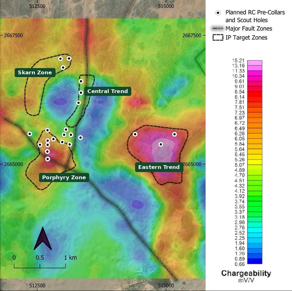
Table 1. Bahila target zones
| Zone | IP | Geology and geochemistry | Rationale |
|---|---|---|---|
| Porphyry Zone | Western trend; chargeable halo from 150 to 250 m, at the fault intersection | Potassic intrusion; magnetic low; Mo halo centre; Cu above 0.5% | Only zone where magnetics, geochemistry and IP coincide; first priority |
| Skarn Zone | Moderate chargeability; defined mainly by surface work | ~1 km garnet-diopside skarn; copper at surface | Second mineralization style at the intrusive contact; second priority |
| Central Trend | Near-vertical body from 50 to 100 m depth, 600 m+ vertical, open north | Porphyritic dyke corridor; >3 km quartz-sericite-pyrite alteration | Possible feeder structure; shallowest IP target |
| Eastern Trend | Strongest response on the property; open south | Largely beyond the surface geochemical footprint | Blind target; tests extent of the system beneath cover |
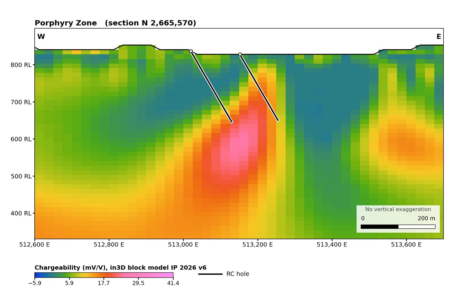
Porphyry Zone: The Porphyry Zone lies at the intersection of the north-south and northwest-trending faults, where the three chargeability trends converge. The zone is centred on a potassic-altered, sulphide-bearing intrusion and the magnetite-destructive magnetic anomaly, and hosts the centre of the molybdenum halo (to 1,450 ppm Mo) and the cluster of rock-chip samples above 0.5% Cu. IP sections image a chargeable halo from approximately 150–250 m below surface, beneath a low-chargeability leached cap (Figure 2). As the only part of the prospect where magnetics, geochemistry and chargeability coincide, the Porphyry Zone is the primary test of porphyry-style mineralization on the property, and the RC holes double as potential collars for diamond tails into the chargeable halo.
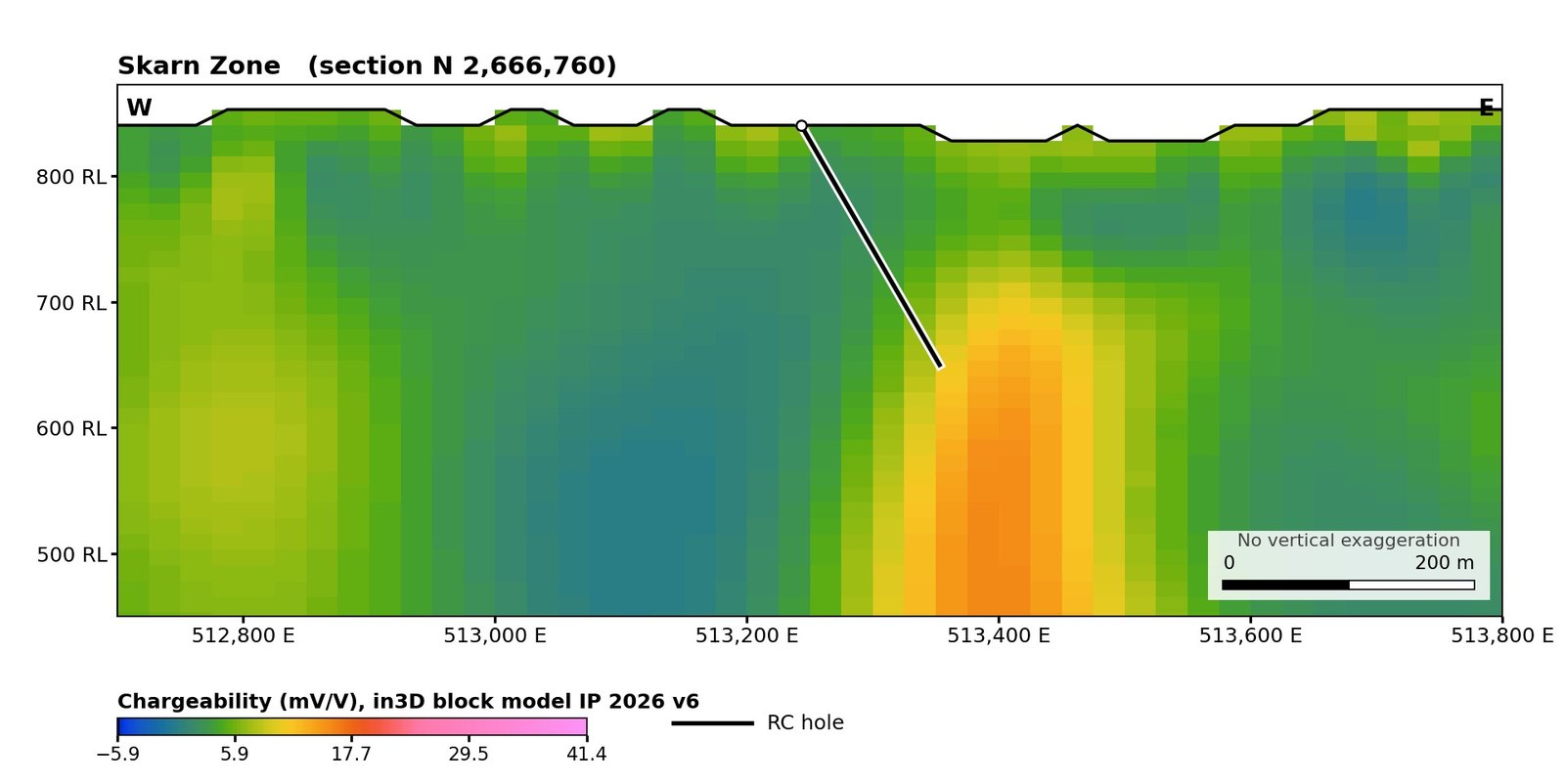
Skarn Zone: Approximately 1 km of garnet-diopside skarn, with copper and zinc mineralization at surface, has been mapped along the northern contact of the intrusion. Skarn on the margin of a porphyry intrusion is a common second style of mineralization in these systems. The zone is defined mainly by mapping and sampling, with a moderate chargeable body east of the skarn from approximately 130 m below surface (Figure 3).
Central Trend: The Central Trend follows the north-south fault for approximately 3 km and is open to the north. IP sections image a near-vertical chargeable body from within 50–100 m of surface, extending at least 600 m vertically and coinciding at surface with the porphyritic dyke corridor and more than 3 km of quartz-sericite-pyrite alteration with disseminated sulphides. In magmatic-hydrothermal systems, sub-vertical chargeable bodies of this geometry are commonly associated with mineralized feeder structures. The Central Trend is the shallowest IP target on the prospect and can be tested efficiently with RC drilling.
Eastern Trend: The Eastern Trend carries the strongest chargeability response on the property, dominates the southern half of the IP grid and is open to the south. The trend lies largely outside the surface geochemical footprint beneath weathered cover. The size and strength of the response make the Eastern Trend a priority test of whether the system extends east beneath cover.
4. Diamond Drilling Follow-up
We expect to use diamond drilling to follow up high-priority targets that extend beyond the depth limit of RC drilling. The strongest chargeability at Bahila, and the deeper magnetic body beneath the magnetic anomaly, lie largely below the reach of the RC holes (Figure 4). Each RC hole narrows the target, and diamond tails on selected holes would test the chargeable bodies and the magnetic body at depth. Diamond core will also provide the oriented structural data and alteration mineralogy needed to vector toward mineralization.
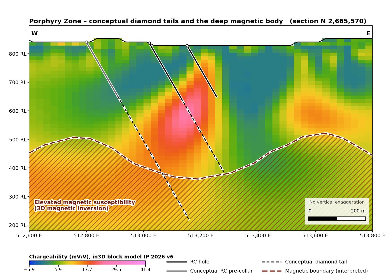
Chargeability measures sulphide content, not copper. The core may represent the sulphide-rich centre of a porphyry system or its pyritic halo.
5. Outlook and Next Steps
The program is designed to determine whether Bahila has the geology of a mineralized porphyry system and where its copper centre lies.
- RC results – the RC holes sample the upper 200 m of the system, generally outside or above the cores of the IP anomalies. The upper and outer parts of porphyry systems commonly carry pyrite-rich alteration with lower copper than the core. We expect the first RC assays to define anomalous copper, molybdenum and pathfinder footprints rather than discovery-grade intersections, and we will use those footprints to direct the diamond tails.
- Diamond results – we expect the diamond tails to test the chargeable bodies and the deeper magnetic body, the parts of the system most likely to host a copper centre if one is present.
- Timing – we expect first RC assays in Q4 2026 and expect to commence diamond drilling later in the quarter.
- Ongoing – completion of a ground radiometric survey and integration of radiometric and hyperspectral data into the targeting model.
About Greyridge
Greyridge Exploration Corp. is focused on discovering copper and gold deposits on underexplored, highly prospective ground in Saudi Arabia. The Company holds 25 licences (1,817 km²) situated on and near defined gold and copper mineral belts of the Arabian-Nubian Shield.
Qualified Person
The scientific and technical information in this update has been reviewed and approved by Darren Lefort, a “Qualified Person” as defined under National Instrument 43-101 – Standards of Disclosure for Mineral Projects. Chargeability and resistivity anomalies are geophysical features that indicate the possible presence of sulphide minerals; they are not measurements of mineralization, grade or tonnage, and there is no assurance that drilling will intersect mineralization. Anomalies described as “open” are unconstrained at the survey boundary; this denotes the limit of geophysical coverage, not demonstrated continuity of any geological feature. Rock chip sample results referred to in this update are selective in nature and are not necessarily representative of the mineralization hosted on the licences. Individual sample assays do not constitute mineral resources or mineral reserves as defined under NI 43-101 and CIM Definition Standards.
Forward-Looking Information
This update contains forward-looking information within the meaning of applicable Canadian securities legislation, including statements regarding the scope, sequencing, timing and completion of the Bahila drill program, the extension of RC holes with diamond tails, the expected timing of assay results, the interpretation of geological and geophysical data, and interpreted deposit models. Forward-looking information is based on assumptions, including the continued availability of the drill rig and crews, laboratory turnaround times consistent with current estimates, the accuracy of the geophysical model at depth and the extent to which RC results are indicative of the geology at depth. Known and unknown risks and uncertainties may cause actual results to differ materially, including exploration risk, the uncertainty of geophysical interpretation prior to drilling and assay, drilling and ground conditions (including water inflow), regional security conditions, equipment availability, commodity-price volatility, permitting, and assay-laboratory capacity. References to deposit-style analogues and to neighbouring deposits (including the Al Amar mine and Khnaiguiyah) are for geological context only; mineralization hosted on, or grades and tonnages associated with, neighbouring properties are not necessarily indicative of mineralization on Greyridge's licences. Readers are cautioned not to place undue reliance on forward-looking information, which speaks only as of the date of this update. The Company undertakes no obligation to update forward-looking information except as required by law.